[av_one_half first min_height=” vertical_alignment=” space=” custom_margin=” margin=’0px’ link=” linktarget=” link_hover=” padding=’0px’ border=” border_color=” radius=’0px’ background=’bg_color’ background_color=” background_gradient_color1=” background_gradient_color2=” background_gradient_direction=’vertical’ src=” background_position=’top left’ background_repeat=’no-repeat’ animation=” mobile_breaking=” mobile_display=” av_uid=’av-3qjnnc’]
[av_textblock size=” font_color=” color=” av-medium-font-size=” av-small-font-size=” av-mini-font-size=” av_uid=’av-johabk3y’ custom_class=” admin_preview_bg=”]
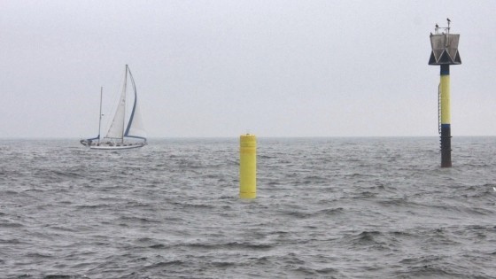
FOR THE FIRST TIME A SMART BUOY WITH OIL SENSOR IS DELIVERING DATA VIA SATELLITE IN OPEN SEA CONDITIONS IN THE BALTIC SEA
A smart navigation buoy system has started in October to deliver real-time measurement data via satellite of oil and some other water quality parameters in the Baltic Sea water. It is located in south of Helsinki in the Gulf of Finland.
Read more
[/av_textblock]
[/av_one_half][av_one_half min_height=” vertical_alignment=” space=” custom_margin=” margin=’0px’ link=” linktarget=” link_hover=” padding=’0px’ border=” border_color=” radius=’0px’ background=’bg_color’ background_color=” background_gradient_color1=” background_gradient_color2=” background_gradient_direction=’vertical’ src=” background_position=’top left’ background_repeat=’no-repeat’ animation=” mobile_breaking=” mobile_display=” av_uid=’av-1ydcco’]
[av_image src=’https://satelbv.nl/wp-content/uploads/2018/11/SeaHow-buoy-communication-300×169.jpg’ attachment=’5653′ attachment_size=’medium’ align=’center’ styling=” hover=” link=” target=” caption=” font_size=” appearance=” overlay_opacity=’0.4′ overlay_color=’#000000′ overlay_text_color=’#ffffff’ copyright=” animation=’no-animation’ av_uid=’av-johacp2h’ custom_class=” admin_preview_bg=”][/av_image]
[/av_one_half]